Showing 2830 items matching public building
-
 Port Melbourne Historical & Preservation Society
Document - DVD, Public Records Office Victoria (PROV), Masonic Hall Port Melbourne. Public Building file, 1967 - 1974
... Masonic Hall Port Melbourne. Public Building file...COPYRIGHT PROV Masonic Hall Port Melbourne. Public... Melbourne. Public Building file COPYRIGHT PROV Masonic Hall Port ...COPYRIGHT PROV Masonic Hall Port Melbourne. Public Building file. DVD containing 10 pages of images of documents to and from the Public Health Department regarding specifications and plans for the Masonic Hall in Liardet St, Port Melbourne in 1917. Plus renewal of registration forms in 1922, 1937, 1941societies clubs unions and other organisations, built environment, health - general health, masonic hall, william howe -
Port Melbourne Historical & Preservation Society
Document - DVD, Public Records Office Victoria (PROV), Seamen's Mission (230 Rouse St) Port Melbourne, Public Building file, 1906
... Seamen's Mission (230 Rouse St) Port Melbourne, Public... Melbourne, Public Building file. DVD containing 14 pages of images... (230 Rouse St) Port Melbourne, Public Building file COPYRIGHT ...NB this does not relate to the Beach and Nott Institute, but to a separate one from Temperance Hall that leased premises in 1906COPYRIGHT PROV Seamen's Mission (230 Rouse St) Port Melbourne, Public Building file. DVD containing 14 pages of images of documents between Rev B Cozens and the Public Health Department regarding conversion of four rented rooms into a Seamen's Mission at 230 Rouse St, Port Melbourne in 1906built environment, transport - shipping, missions to seamen, societies clubs unions and other organisations, rev b cozens -
Port Melbourne Historical & Preservation Society
Document - DVD, Public Records Office Victoria (PROV), Temperance Hall, Port Melbourne, Public Building file, 1890 - 1963
... Temperance Hall, Port Melbourne, Public Building file...COPYRIGHT PROV Temperance Hall, Port Melbourne, Public... PROV Temperance Hall, Port Melbourne, Public Building file ...COPYRIGHT PROV Temperance Hall, Port Melbourne, Public Building file. DVD containing 25 pages of images of letters, documents and plans concerning the Temperance Hall, corner Nott and Liardet Streets, Port Melbourne from 1890 to 1963, belonging to the Independent Order of Rechabites. 1963 documents relate to the sale of the building to Port Melbourne Council for use as an Elderly Citizens Centrebuilt environment - civic, local government - city of port melbourne, societies clubs unions and other organisations, health - general health, port melbourne temperance hall, edward clark, town clerks, senior citizens centre, liardet community centre -
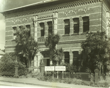 City of Ballarat Libraries
Photograph, Ballaarat Public Library Building, Barkly Street
... Ballaarat Public Library Building, Barkly Street.... This building housed the original Ballarat Public Library. Sir Redmond ...An image from the Herbert Richmond collection, gifted in 1982 to the Ballarat Library. The collection contains approximately 200 photographs of Ballarat and district in the 1940s, 50s and 60s, as well as photo albums, glass negatives and other memorabilia. Herb Richmond was a keen photographer, a foundation member and a life member of the Ballarat Camera Club, and a photographer with the Ballarat Courier during the 1940s. The Ballarat Camera Club named an annual award after him. Mr Richmond died in 1981 aged 79. These images were digitally re-photographed by members of the Ballarat Camera Club in September 2006. This building housed the original Ballarat Public Library. Sir Redmond Barry laid the foundation stone in 1867. The building was part of the Ballarat East civic area which included the Ballarat East Town Hall and Police Court, both since demolished and replaced with the Ballarat Girls School building - which is now standing empty (2017).barkly street, ballaarat municipal libraries, ballaarat historical society, historical museum, ballarat east -
Tatura Irrigation & Wartime Camps Museum
Book, Public Library of NSW, 1943
... public building...To mark the completion of the Public Library Building, 1943... to the Building To mark the completion of the Public Library Building ...To mark the completion of the Public Library Building, 1943- Library of NSWA brief guide to the Buildingpublic building, books, history, local -
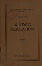 Federation University Historical Collection
Book, Department of Public Health Victoria Building Regulations, 1937
... Department of Public Health Victoria Building Regulations... Department of Public Health Victoria Building Regulations, 1937 Brown ...Brown soft covered book building, regulations, department of public health, victoria, health acts, overcrowding, application, exits, drainage, closets and urinals, ventilation, health department -
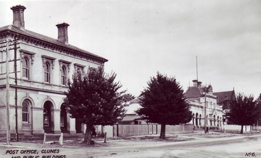 Clunes Museum
Photograph
... "POST OFFICE, CLUNES AND PUBLIC BUILDINGS"... AND PUBLIC BUILDINGS" photography post office ....1 BLACK AND WHITE PHOTOGRAPH, (ENLARGEMENT) SHOWING CLUNES POST OFFICE, TOWN HALL, COURT HOUSE, WITH ST. THOMAS AQUINAS CHURCH IN BACKGROUND .2 BLACK AND WHITE PHOTOGRAPH, (ORIGINAL) SHOWING CLUNES POST OFFICE, TOWN HALL, COURT HOUSE, WITH ST. THOMAS AQUINAS CHURCH IN BACKGROUND .3 BLACK AND WHITE PHOTOGRAPH, (COPY) SHOWING CLUNES POST OFFICE, TOWN HALL, COURT HOUSE, WITH ST. THOMAS AQUINAS CHURCH IN BACKGROUND"POST OFFICE, CLUNES AND PUBLIC BUILDINGS"photography, post office -
Clunes Museum
PHOTO ALBUM
... PHOTOGRAPH ALBUM DEPICTING PUBLIC BUILDINGS IN CLUNES... ALBUM PHOTOGRAPH ALBUM DEPICTING PUBLIC BUILDINGS IN CLUNES ...COLLINS PLACE - FOUR SHOP FRONTS IN FRASER STREET. 3 HAVE BEEN RESTORED. PRIVATE GARDENS SPILLING INTO STREET. CLUNES BOWLING CLUB - ST. THOMAS AQUINAS CATHOLIC CHURCH - CLUNES POST OFFICE - TOWN HALL & COURT HOUSE - R.S.L.BUILDING - A.N.Z BANK - 2 FORMER PUBS REFURNISHED I.E KEEBLES, THE RAILWAY HOTEL - MASONIC LODGE - FREE LIBRARYPHOTOGRAPH ALBUM DEPICTING PUBLIC BUILDINGS IN CLUNESlocal history, book, album, buildings -
 The Beechworth Burke Museum
Photograph, c. 1900
... public building... several public buildings such as the Benevolent Asylum... sums to establish several public buildings ...This black and white photograph shows the front view of the Ovens Benevolent Home with one person sitting on a bench seat against the nearest part of the building and another person walking on the grass. This photo is estimated to have been taken in the early 1900’s when the Ovens Benevolent home would have still been fairly contemporary. According to Woods (p. 121) in the 1860’s the government spent considerable sums to establish several public buildings such as the Benevolent Asylum, the Hospital and Insane Asylum to support those in need of care in the area directly after the Indigo gold rush which had left Beechworth, a fairly remote regional and newly formed township (Gold was first discovered in Beechworth in 1852) with a number of infirm and destitute people in its wake and which due to the support and establishment of these facilities ‘made Beechworth a significant social welfare centre in Victoria’ (Woods, p. 121). Originally named the Benevolent Asylum, the building was renamed as The Ovens Benevolent Asylum in 1935 and again to The Ovens and Murray Home in 1954. The building construction began in 1862 and was unique in its features of Flemish Gothic Revival style which utilised red brick and granite, ‘the main facade is dominated by four curved, Flemish gable ends, […] incorporates paired windows of pointed Gothic form and dark brick diaperwork patterning. The adjacent J. A. Wallace Wing of 1899 was designed by Donald Fiddes as a separate building. Also constructed of red brick, Fiddes adopted a conservative approach, designing a simple domestic scale building with central projecting gable porch and flanking bull nosed verandahs.’ (https://vhd.heritagecouncil.vic.gov.au/places/118). Initially established to provide housing and care for aged, orphaned or widowed members of the population, over time the Ovens Benevolent Home focused more on the age care responsibility which functioned as such up until 2005.The Ovens Benevolent Home is significance due to its association with the early development of Beechworth. It shows the civic, social welfare development that took place in the town after the peak of the gold rush which helps to establish the character of the community being built at the time and their cultural values at play. This photograph also clearly shows the early functioning landscape of that building and its purpose as well as the significant elements of its aesthetic significance and unique and striking architectural forms of the building.Black and white rectangular photograph [copy from slide]Reverse: / 7588 /housing and care, aged care, donald fiddes, ovens benevolent home, flemish gable, brick diaperwork, photograph, black and white photograph, public building, benevolent asylum, indigo gold rush, beechworth, the ovens and murray home -
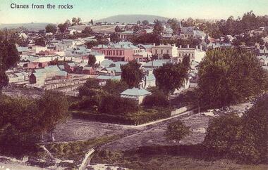 Clunes Museum
Photograph, PRINTED IN GERMANY
... BANKS AND PUBLIC BUILDINGS IN FRASER STREET.... BANKS AND PUBLIC BUILDINGS IN FRASER STREET. CLUNES FROM ...COLOURED POSTCARD OF VIEW OF CLUNES - TAKEN FROM THE ROCKS COLOURED COPY OF PHOTOGRAPH OF CLUNES TOWNSHIP, SHOWING BANKS AND PUBLIC BUILDINGS IN FRASER STREET.CLUNES FROM THE ROCKSlocal history, document, postcard, clunes township -
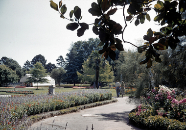 City of Ballarat Libraries
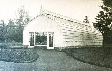
35mm Slide, Keel Glasshouse at the Botancal Gardens circa mid 1950s
... public building... glasshouse garden building public building ballarat botanical garden ...A delightfully framed shot of the Botanical Gardens in the mid to late 1950s. We can be reasonably sure of the date of this image because it shows the Keel House conservatory. Designed and fabricated in England, it was then re-assembled in the Ballarat Gardens in 1906. It was purely for display, only allowing public viewing through glass windows at either end. It became known as the Keel House because the roofline resembled a boat hull. The Keel House was replaced in 1959 by Cuthbert House, another conservatory which also did not allow public access. Cuthbert House was replaced in 1995 by the present Robert Clark conservatory, which allows public access for the first time. Note other details in this photograph, the sprinkler at full bore and the little boy hiding behind the sundial. Mrs Bon Strange and her husband Bert were well known Ballarat residents. When Mrs Strange died some years ago, her extensive slide collection was sorted through and those relevant to Ballarat were gifted to the Ballarat Library.greenhouse, glasshouse, keel glasshouse, garden, building, public building, ballarat botanical garden -
 City of Ballarat Libraries
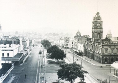
Photograph, Panorama view of Sturt Street circa 1870
... . panorama commerical public building gadens sturt street streetscape ...This view is from the Post Office tower looking south. Things of interest include the Town Hall, the Burke & Wills Monument, Cobbs Corner and the Mechanics' Institute.panorama, commerical, public, building, gadens, sturt street, streetscape -
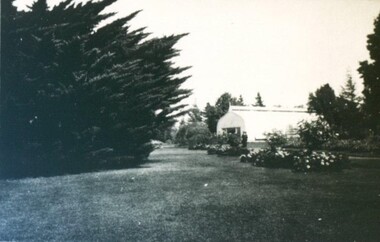 City of Ballarat Libraries
Photograph - Card Box Photographs, Keel Glasshouse at the Ballarat Botanical Gardens 1923
... public building... conservatory ballarat botanic gardens gardens public building ...keel house, conservatory, ballarat botanic gardens, gardens, public building -
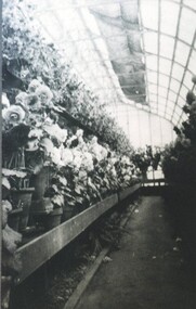 City of Ballarat Libraries
Photograph - Card Box Photographs, Interior of the Keel Glasshouse, Ballarat Botanic Gardens 1923
... public building... house ballarat botanic gardens garden public building begonias ...This photograph was taken as the Begonias were in full bloom at Easter 1923.keel house, ballarat botanic gardens, garden, public building, begonias -
 City of Ballarat Libraries
Photograph - Card Box Photographs, Ladies Highland Pipe Band
... public building... brigade hotel sturt street raglan street queen's visit public ...The Ladies Highland Pipe Band pass the City Brigade Hotel on the corner of Sturt and Raglan Streets on the occasion of the Queen's visit 1954.ladies highland pipe band, city brigade hotel, sturt street, raglan street, queen's visit, public building, hotel, celebration, ballarat -
 City of Ballarat Libraries
Photograph - Card Box Photographs, Keel Glasshouse, Ballarat Botanic Gardens circa 1915
... public building... ballarat botanic gardens garden building public building ...keel glasshouse, ballarat botanic gardens, garden, building, public building -
 City of Ballarat Libraries
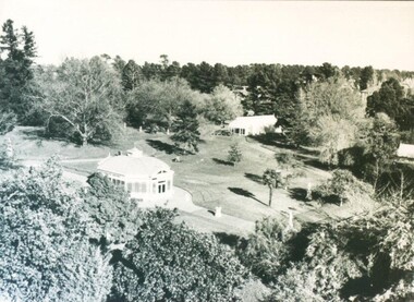
Photograph - Card Box Photographs, The Statuary Pavilion & Keel Glasshouse, Ballarat Botanic Gardens circa 1910
... public building... glasshouse garden building public building ...ballarat botanical gardens, statuary pavillion, keel glasshouse, garden, building, public building -
 City of Ballarat Libraries
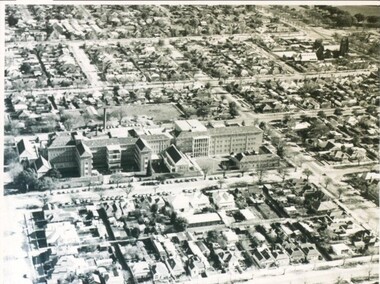
Photograph - Card Box Photographs, Queen Elizabeth Geriatric Centre, Ballarat circa 1945
... public building... ballarat ascot street building public building medical ...Aerial view of the QEGC on Ascot Street.queen elizabeth geriatric centre, qegc, ballarat, ascot street, building, public building, medical -
 City of Ballarat Libraries
Photograph - Card Box Photographs, Ballarat Town Hall & Sturt Street circa 1936
... public building... public building commerical ...You can see the Town Hall and both sides of Sturt Street looking east. Some of the business include Crockers and Tunbridges.ballarat town hall, sturt street, streetscape, electric tram, garden, crockers, tunbridges, vehicle, building, public building, commerical -
 City of Ballarat Libraries
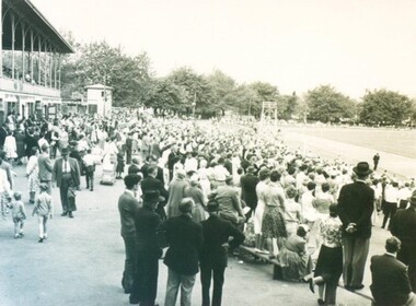
Photograph - Card Box Photographs, Spectators at the City Oval, Ballarat circa 1955
... at the City Oval, Ballarat circa 1955. city oval ballarat public ...city oval, ballarat, public, building, grandstand, sport, pleasant street, sturt street -
 City of Ballarat Libraries
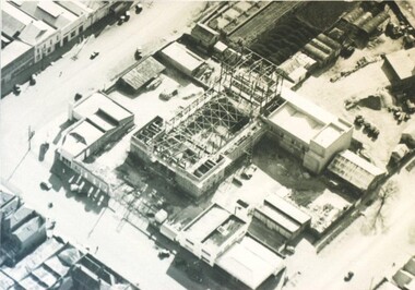
Photograph - Card Box Photographs, Aerial view of the Civic Hall under construction, Ballarat circa 1951
... public building... armstrong street north building construction public building ...This photo shows the buildings still standing around the Civic Hall as it was being constructed.civic hall, ballarat, mair street, aerial view, armstrong street north, building, construction, public building -
 City of Ballarat Libraries
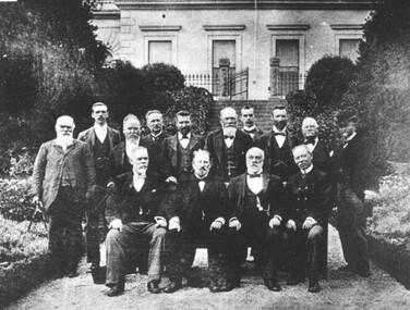
Photograph - Card Box Photographs, Ballarat East Mayor and Councillors circa 1902
... Public Building Gardens Mayor ...The Mayor and Councillors are photographed at the back of the Ballarat East Town Hall in the gardens.ballarat east, ballarat east town hall, public, building, gardens, mayor -
 City of Ballarat Libraries
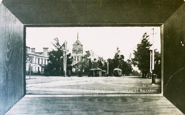
Postcard - Card Box Photographs, Ballarat Base Hospital, circa 1905
... Drummond Street North Streetscape Public Building Vehicle Tram ...View north east along Drummond Street North. Hospital still has it's tower.ballarat base hospital, drummond street north, streetscape, public, building, vehicle, tram -
 Bayside Gallery - Bayside City Council Art & Heritage Collection
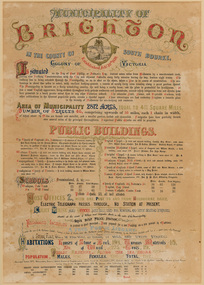
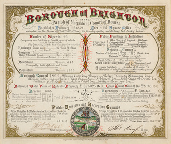
Certificate - Illuminated certificate, Brighton Municipal Certificate, 1861
... size of the municipality, number of streets, public buildings... of the municipality, number of streets, public buildings, schools, churches ...bayside city council, borough of brighton, illuminated, certificate, population, public buildings, surveyor, council, borough, county of bourke, census, colony of victoria -
 Damascus College
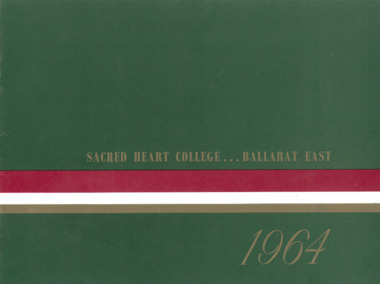
Magazine - 1964 Yearbook, Sacred Heart College Ballarat East 1964
... of the first public appeal for building funds made by the Sisters... and is an appeal to the public for building funds with the aim of raising... to the public for building funds with the aim of raising £80,000 ...Publication documenting the 1964 school year16 page publication with colour cover and black and white images. The magazine documents the activities of the school and is an appeal to the public for building funds with the aim of raising £80,000.non-fictionPublication documenting the 1964 school yearballarat, sisters of mercy, catholic education -
 Bendigo Historical Society Inc.
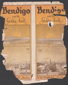
Booklet - Bendigo and the Golden North
... 8537 Booklet presenting the public buildings, churches... presenting the public buildings, churches, recreation facilities ...8537 Booklet presenting the public buildings, churches, recreation facilities, industry and parks and streetscapes of Bendigo in the early 1900s. Booklet is presented in B&W with numerous photographs of buildings and streetscapes of the city off Bendigo.golden north, tourist guide, notable buildings -
 Bayside Gallery - Bayside City Council Art & Heritage Collection
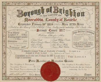
Certificate - Illuminated certificate, Brighton Municipal Certificate, 1872
... of councillors, number of streets, public buildings and institutions... of councillors, number of streets, public buildings and institutions ...bayside city council, borough of brighton, illuminated, certificate, population, rates, public buildings, wp allen, mayor, town clerk, surveyor, councillors, council, borough, county of bourke -
 Bayside Gallery - Bayside City Council Art & Heritage Collection
Certificate - Illuminated certificate, Hamel & Fergsuon, Brighton Municipal Certificate, 1866
... list of councillors, number of streets, public buildings... of councillors, number of streets, public buildings and institutions ...bayside city council, borough of brighton, illuminated, certificate, population, rates, public buildings, mayor, town clerk, surveyor, councillors, council, borough, county of bourke, thomas crisp, cr t. crisp, census, parish of moorabbin, hamel & ferguson, coat of arms -
 Bayside Gallery - Bayside City Council Art & Heritage Collection
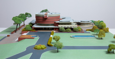
Model, Alan W. Chandler, Brighton Municipal Complex, 1959
... Architectural model of a large public building in orange... of a large public building in orange brick, the main cylindrical ...This model of the Brighton Municipal Offices was made by Alan W. Chandler. The Brighton Municipal Offices were designed by Kevin Knight of Oakley and Parkes with the engineers John Connell and Associates and were erected by Prentice Builders Pty Ltd. The foundation stone was laid on 13 February 1959 and the building was opened on 21 July 1961. The interior decoration and furniture was by Grant Featherston. As is common practice, an architectural model was prepared to present the final concept of the building for approval to the Brighton City Council. In February 1959 festivities occurred to celebrate the centenary of the municipality of Brighton. A garden party attended by two hundred Brighton residents was held in the grounds of the Brighton Town Hall. This model graced the centre of the lily pond during the event. The following day the foundation stone of the Brighton Municipal Offices was laid.Architectural model of a large public building in orange brick, the main cylindrical tower is set within a rectangular structure, with circular and oval roof structures. The model is set within landscaped grounds with paths, a water feature, several trees and bushes, lawns and flower beds.brighton municipal complex, brighton civic centre, brighton chambers, architectural model, model, alan w. chandler, kevin knight, oakley and parkes, architecture, municipal offices, municipal building, scale model -
 Flagstaff Hill Maritime Museum and Village
Document - Framed Poster, Borough of Warrnambool, Victoria, Australia, after 30/06/1875
... and facilities, public buildings and institutions, imports and exports... location, public buildings and institutions, harbor facilities... in 1875. It states geographic location, public buildings ...This document, also referred to as a word picture or Tablet, is framed in glass and timber with gilt trim, is handwritten with colour highlights. The penned letters rest on ruled guide lines, decorated where the lines intersect. The writing gives a description of the state of Borough of Warrnambool around 1875; its location, the area it covers, its population, Harbour and facilities, public buildings and institutions, imports and exports, financial worth, number of houses, connection with other areas of the Colony. A possible reason and origin for the document is found in an article ‘Link with US Exhibition’ from the Warrnambool Standard of December 19, 1981, written by local historian Bruce Morris. The writer mentions that the Warrnambool Borough Council met on 15th June 1875 and recorded a letter from G.C. Levey , secretary to the Melbourne group of commissioners representing the Colony, and Victoria in particular, for the Philadelphia Centennial Exhibition of 1876. The letter asks Council to provide “statistics as to the population, social condition and commercial and industrial state of the district in and around Warrnambool.” A sub committee was formed for the project. The Mayor, Cr. Thomas King, wrote and signed a Report, presented to the council on July 14, 1875, in which “The Committee … begs to recommend that a Tablet be prepared setting for the particulars respecting the following matters relating to the Borough”. The matters included area, population, annual income, churches, schools, other public buildings, societies and companies, general description of houses erected, and returns of exports and imports for 1874. The minutes note that the Report was adopted. The article above also notes the opinion of Warrnambool printers who have examined the document; it is almost certainly to be an old lithograph, which means there could be several copies. It is possible that there may be a copy in Melbourne and another in Philadelphia. It is interesting to note that (1) the quoted location co-ordinates are for an “Unnamed Road, Packsaddle NSW 2880, Australia”, and that the DMS co-ordinates for Warrnambool’s Council Offices differ, being 38.23.9.12 South, 142.28.52.887. (2) the date for “Exports and Imports for the Year Ending 30th June 1875” is different to the period mentioned by Cr. King in the sub committee’s Report of recommendation “returns of exports and imports for 1874”. The information required to have the figures for the end of June 1875 would need to have been compiled very quickly for the Tablet to be ready for the opening of the Philadelphia Exhibition on 10 May 1876. The document/certificate shows the following – - - - - - - - - - - - - - - -- - - - - - - - - - - - - - -- - - - - - - - - - - - - - -- - - - - - - - - - - - - - - “Victoria Australia, Borough of Warrnambool. Latitude, 30.24.50 South, Longitude 142.32 East The Principal Port in the Western District of the Colony and the Centre of its Choicest Agricultural Lands. Established a Municipality in 1855, and Created a Borough 1863. Population in 1875 4,500. Warrnambool is the nearest Port to Melbourne on the Western Seaboard, being about 160 miles distant. Coaches run to and from the Metropolis daily, in connexion [connection] with the Railway of Geelong and Steamers belonging to Local Companies sail between Melbourne, Warrnambool, Belfast [renamed Port Fairy], and Portland several times weekly. The Harbour is known as Lady Bay, and is partially protected by a reef of rocks stretching from the mouth of the Hopkins River. The formation of a Breakwater has been decided upon by the Government, to extend 600 yards, at an estimated cost of £100,000. There are two substantial Jetties, one of 800 and the other of 600 feet in length. The former is connected with the Town by means of a Tramroad, along which Goods, inwards & outwards, are conveyed, & the latter has been constructed solely for the purpose of facilitating the transit of material for the formation of the Breakwater. In addition to the trade of the Borough and District, the principal Townships up country receive their supplies from Melbourne and ship their exports through Warrnambool. Potatoes form the staple produce of the district, and the richness of the soil can be estimated by the fact that the Government Statistics for 1875 give as the average yield a return of Seven Tons to the acre. Several thousand acres between Warrnambool and Tower Hill are now being laid down in Potatoes by Tenants who have leased the lands at rates up to £5 per acre for the season 1875-6. Wool, Tallow, hides &c are also largely exported, while the shipments of all descriptions of Farm Produce are annually increasing. Area of Borough, 3362 Acres. Net Annual Value £27,000. Annual Revenue £5,500. Number of Houses in Borough 800. Public Buildings and Institutions Churches. Church of England, Roman Catholic, Presbyterian, Wesleyan, Congregational and Baptist. Schools. Three State Schools, average attendance nearly 1000. New Building in course of erection. Several private establishments. Banks. Bank of Australasia, Bank of Victoria, National Bank, Colonial Bank and Savings Bank. Public Buildings. Court house, Custom house, Post & Telegraph Offices, Survey & Land Offices, Shire £, Town Hall, Mechanics Institute, Volunteer Orderly Room, Odd Fellows Hall, Hospital & Benevolent Asylum, Temperance Hall &c. Companies & Societies. Steam Navigation Co, Woolen Mill Co, Gas Co, Racing Club, Amateur Turf Club, Agricultural Society, Farmers’ Club, Cricket Club, Anglers’ Society, Building Society, Freemasons Odd Fellows, Foresters, Druids, Hibernians. Protestant Alliance, Rechabites, Sons of Temperance, &c, Fire Brigade &c. --- Exports and Imports for the Year Ending 30th June 1875 –-- --Exports Total Tonnage 27,800 (Calculated at the Current Warrnambool Market Prices) Potatoes Wool Wheat Barley Hides Skins Fowls Butter Cheese Eggs Tallow Leather Ale Pigs Sheep Sundries --Imports 13,000 Tons Of the Estimated Value of £520,000 Total Tonnage of Exports and Imports 40m900 Tons, Value £806,627 Passenger Travels, to ad from Warrnambool during year, 10,000 persons Revenue from all sources paid through Warrnambool Sub Treasury From 1860 to June 1875 £1, 292, 300 Thomas King [signed] Mayor Henry T Read [signed] Town Clerk” - - - - - - - - - - - - - - -- - - - - - - - - - - - - - -- - - - - - - - - - - - - - -- - - - - - - - - - - - - - - The document is of historical, social, economic and local significance in that it summarises activities, business, community, trade, travel and government at a point in time in Warrnambool’s history – 30th June 1875.Document, also referred to as a ‘word picture’ or ‘tablet’. Document is framed in glass and timber with gilt trim, handwritten with colour highlights. The penned letters rest on ruled guide lines, decorated where the lines intersect. Document outlines the establishment of Warrnambool as a Municipality in 1855 and Borough in 1863, with a population of 4,500 in 1875. It states geographic location, public buildings and institutions, harbor facilities and imports and exports for the year ending 30th June 1875. Two signatures "Thomas King" Mayor and "Henry T Read" Town Clerk. It shows the Coat of Arms of the Borough of Warrnambool.Signatures - "Thomas King" Mayor and "Henry T Read" Town Clerk. Warrnambool Coat of Arms; “British Coat of Arms, above sailing vessel and sheaf of wheat in sun, motto “By these we flourish” and around circumference “Borough of Warrnambool 1855”flagstaff hill, warrnambool, shipwrecked coast, flagstaff hill maritime museum, maritime museum, shipwreck coast, flagstaff hill maritime village, great ocean road, borough of warrnambool, municipality of warrnambool, document borough of warrnambool 1875, word picture of warrnambool 1875, tablet of borough of warrnambool 1875, statistics borough of warrnambool 1875, lithograph borough of warrnambool 1875, coat of arms warrnambool, warrnambool city motto – in these we flourish, establishment of warrnambool, warrnambool history, thomas king mayor of warrnambool, henry t read town clerk of warrnambool, warrnambool breakwater, warrnambool jetty, warrnambool imports and exports 1875, warrnambool agriculture 1875, warrnambool business 1875, warrnambool population 1875, centennial exhibition philadelphia 1876